The history of life on earth starts with water. Present in the gaseous form on earth or brought by meteoric showers from space, we know not, but that was one of the building blocks of life. The importance of it can't be much emphasised as all the ancient civilisations are river valley civilisation.
The Indian subcontinent lies in a tropical zone, just 5 degrees north of the equator, and the major source of water is the monsoon. From early June till September, there are torrential downpours, brilliant sunshine, and mist of clouds swills that roll down in the Western Ghats, and when it returns, it brings back showers to the rain shadow regions of Western Ghats. The bounty kept people happy, and vagaries dreaded them. So effectively they employed every other science to store and use them.
The Brihat Samhita (Brihat translates to Large or scope, which is various) by Varahamihira contains many scientific discourses, and out of 33 chapters, 10 are devoted to meteorology. The formation of clouds (Garbhalakshanam), and once the rain touches the earth, the nature of the water (astringent, acidic, or just pure and fresh). The Artha Shastra of Chanakya observes a correlation between two natural events and tries to figure out the cycle with them. "Venus appears in the eastern sky for about eight months, and after the short disappearance, comes back on the western sky during the evening. The synodic period of it is about 19 months. Hence, if Venus is spotted in the early part of the monsoonal season, it would not be available on the spot the next season. By the time the cycle returns, it's nearly three years which is known as El Nino southern oscillation" *. Later, various cyclical patterns developed as thumb rules as the stars, the house which it conjugates, and the year, according to the Indian calendar, for prediction of rainfall.
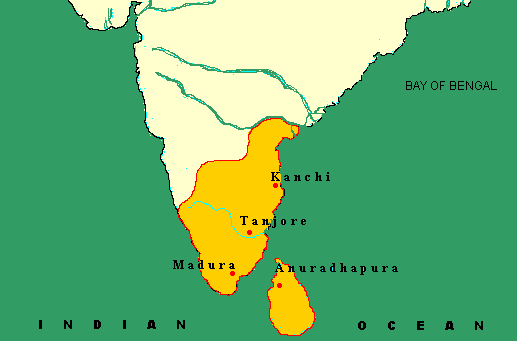
Ancient Indians were well conversant with the way clouds are formed, the prediction of rainfall, measuring them, underwater sources, water tables, the nature of the slope of the earth's surface, and a well-placed way to store and utilise them with great empathy towards it. Water was precious and treated with veneration. The story of the water management of Cholas is the story of the attempt to utilise this resource to the maximum extent possible.
The winds not only brought rains but also trade too, and all produced were (including pearls) sold to distant nations. It is to be remembered that the Indian Ocean was much frequented by Cholas. Raja Raja had captured the Maldives, back then called Pazhan Thevu. Later, Rajendra Chola led a naval expedition around the fifth year of his reign around 1020 CE to these islands, capturing the Chera's crown and a garland made from precious red stones.
Cholas realm had sent three embassies to Song China, and when they felt they are being manipulated by the Srivijaya they went on with their Kadaram naval campaign. The inscription records victories of over thirteen South Asian ports covering the gulf of Thailand and reaching the Gulf of Tonkin. Kadaram Kondan was one of the favourite titles which Rajendra Chola liked and adorned himself with. None of the conquered territories was annexed into the Chola's territory. It's also to be hinted that before Chola's offensive, Sri Vijaya had a confrontation with the King of Java King Airlangga. It's hard not to draw a parallel between the political similarity of south Kanara regions and Malabar's Cochin and Calicut with the advent of Europeans for partaking in the riches of the trade.
The Linchpin of Chola's hegemony was not just their trade but the strong internal administration of the riches that their land produced. It was a strong agricultural economy with an excellent irrigation infrastructure with available science. The story of Greater Cholas really starts with Aditya Chola, who established himself by defeating Aparajitha Pallava, and from Pranthaka Chola's time, the focus was to make the land well connected with the river. Veeranam eri, Cholagangam, and channels like Singalantakan, Irumudicholan, Sri Prantakan, and Uyakondan to name the important ones.
During Raja Raja Chola's reign, the land was measured across the country astutely. In 1001 CE, his generals Kuravan Ulaganadhan, Raja Raja Marayar, and Thiruvadi Sathan were entrusted with the measurement. A staff which measured was called Ulagualandhan Kol or Sitrambala Kol which was 16 inches. This process of measuring was in place till Kulothunga III, 1216 CE. Additional lands which were captured were measured and added. The land was broadly classified into Neer Nialam, Kollai, and Kadu. The first two are cultivable lands, which are further divided into Nansai and Punsai. The common denomination was Kuzhi, Ma, and Velli, progressively and still in practice in that part of the country.
The ancient measurements were sharp as their lowest denomination started with a picometer. While leaving taxes, the land's proximity to the water resource, whether it's rain-dependent, was taken into consideration.
Chanakya states the land was classified based on the amount of rainfall received; if the land receiving less than 16 dronas (25 inches) was recorded as land suitable for dry crops, and if the rainfall was 1.5 times the former, it was suitable for wet crops. The classification of the lands and the amount of rainfall is recorded even till Konkan. He later goes on to describe the functioning of irrigation channels, maintenance of tanks, leasing and mortgaging them, tax exemptions if the tank is newly constructed, ways to prevent the malpractices, and punishments if found guilty. For certain crimes, severe punishments were attested, including capital ones, which Cholas shared the thought with.
"During the rule of the Cholas, these rules were further modified and well defined and strictly enforced. An interesting inscription of Parakesarivarman Uttamachola found in Konerirajapuram details the condition of the grant as: "These lands (shall enjoy the privilege of) being irrigated by channels dug out (as per rules) for the distribution of water, others shall not cut or dig out diversions from these channels, nor bale water by the baskets, nor obstruct (the flow) with cross banks. The water (thus made) available must not be wasted; the water must be economically used'. "Canals flowing across other villages to irrigate the land of this village and vice versa shall not be permitted to overflow over the boundary line and to cast-up slit. Besides, the embankments of tanks shall be allowed to be raised within their limits so that they may hold the maximum quantity of water".
The oldest recorded water storage in India comes from the Girnar mountains of Saurashtra, where an Ashokan edict says the structure was built by Chandragupta Maurya. Ashoka's Yavana governor named Tushashpa had said to have strengthened it and introduced sluices in it. The dam was called Sudarshana. The water body had given away thrice and was rebuilt again and again by Kshatrapas using stones. The final ruler who maintained it was a Vakataka ruler of Vidarbahan around 458 CE.
Grand Anicut built by Karikala Chola in the 2nd century, is considered to be among the oldest working water diversion structure in the world. Indian irrigation and drainage committee estimates with the recorded data that flood to the extent of about 1,86,000 cusecs would have been discharged, given the times, where the structure was only one on the river's way, it would have been higher. "It is believed that large cyclopean granite stones would have been brought and dumped across the flowing stream and continuously replenished as these boulders sank on the sandy bed, by their own weight until they got well embedded in the clayey layer below. When the structure, thus, rose above the water level, the weir should have been formed to the crest level as we see it today". Like hammering a nail, gravity is used as kinetic energy.
 "The Anicut consists of a core of rough stones in clay covered with a facing of rough stone in mortar. A portion of the crest was built with a curved top and the rest with a series of steps, the foot of the solid dam being protected by a rough stone apron. The Anicut is 329m (1080 ft) long, 12.20 m to 18.30 m (40ft to 60ft) in width, and 4.57 m to 5.49 m (15ft to 18ft) high. The main function of this anicut is to retain the water in Cauvery and its branches in the Delta by raising the water level and pass on the surplus into Coleroon (River Kolidam) arm just a kilometre off to the north through the Ullar river."
When Sir Arthur Cotton wanted to desilt the river and ensure adequate flows, he wanted to introduce sluices. While he opened the foundation, the 1600-year-old structure, the stones were embedded with native clay and, holding up with sheer gravitational weight, stood unmoved. What exactly constituted the bonding substance goes under the list of mysteries from Chola's reign.
We cannot ascertain it currently as Sir Arthur then order for closure of the foundation with concreting the new addition. As the current structure is very important, a detailed study of the foundation is still referred to as it performing fine, and none want to disturb it. Sir Arthur Cotton, taking that inspiration, applied the idea to River Godavari, where he built barrages using loose piles of mud and stone and covered them with lime.
Lime was used in some form mostly for waterproofing or for cementing purposes since the days of the Maurya period. (Excavation of Besganar MP). The stones should have been covered with a kind of lime veneer as part of waterproofing the cementing material and thus protecting the embankment.
There are about 1505 such main channels in the Cauvery delta, all of the ancient origins with their distributaries, minors, and so on, providing the water carrier system spread out in the Delta; hundreds of weirs and ancients were built across streams as part of gravity irrigation, which fills various chains of lakes.
The control for these sluices was through strong timber shutters, which were made to slide on the grooved stone wall or the heavy cone-shaped weight of the stone that plugged the outlet. We find various of these sluices on any excavation of the ancient tanks. One such engraving from lake Thenmudinur, Tiruvannamalai (Vikrama Chola era by village head Shozhandhaga Pallavaraiyan) read, "I will protect the persons who volunteer to protect this lake by holding their foot on my head." It's very hard not to miss the nobility of the statement. The sluice provided adequate protection downstream to take the impact of the water until the tank was full. Large-sized stones were used in aprons and steps to reduce the disintegration, which may be caused by the flow of water.
The eastern part of the southern peninsular is like a sliding tabletop. The lower surfaces of the Mysore plateau are between 1000 to 1300 feet above sea level; from this to the coast, it's a gentle slope. The geological society of India has observed that the river Cauvery has earlier flowed northeastern and emptied herself in Chennai, the upliftment of Bilgirirangan hill ranges, forced river Cauvery to migrate south. River Palar once represented the former River Cauvery as a river with great water discharge. The Paleo courses of river Cauvery suggest she migrated towards Hohenekkal- Harur and present-day Ponnaiyar Delta and later enters Trichy- Tanjore plains. From Tanjore plains, she initially flowed even further south of the Delta Mannarguri - Vedaranniyam region and later gradually migrated in anticlockwise to reach the present-day track. The change, of course, starts from 3000 y.b.p (years before the present) and settles down to 750 y.b.p.
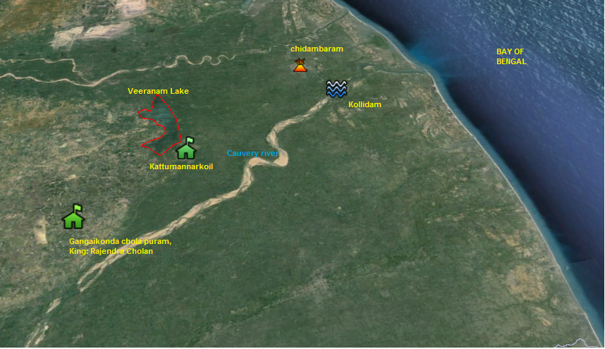
And incidentally, if you look, Cholas would have gone with the natural flow of constructing some major irrigation works to the north of River Kollidam. Even till the 1970s, artesian wells would throw up water up to the height of 10 feet above the ground level (a rarity nowadays in farming areas) when dug in around the current delta area, especially about places near Chidambaram and surrounding places, proving interdependency of ground-level water and the storage of water tanks and bunds much possible.
During Adi peruku, the whole of the Chola country comes alive. The Veeranam lake would fill up, and as its sight to see the massive water body to the brim, like an ocean but the water as sweet. All along the banks of the river, the atmosphere would be festive, as people come as a family, pray, indulge in good food, and kids have a fun time with mother Kavery. A very satisfying feeling it is.
The later Cholas ruled for nearly 450 years. The second-longest monarch was Parnthaka Chola, with lofty forty-six years. It was in the time of Prantaka that his son and Chola's crown prince Rajadhthiya founded Veeranam lake. Lying in the east coastal plans and about 30 km from Chidambaram, its vastness is about 24km north-south and 8 km east-west. Getting continuous feeds from River Vadavar, which channels out from River Kollidam. This river was earlier known as Veerachola Vadavaru and was engineered to join the Veeranam Eri during the King's time. More to it, he had excavated many deep streams and some important channels which were named after his titles. Singalantakan, Irumudicholan, Sri Prantakan are mentioned in Karandai plates.
Though it's not the biggest tank in Tamilnadu, it serves the largest ayacut (extent of the land irrigated). The tank now carries 28 sluices, and when it was initially built, it was supposed to have 74, which carries a profound bond with Sri Ramanuja Sri Vaishnava sampradaya.
Another major water body by Chola's was built by Rajendra Chola in his victorious city of Gangakonda Cholapuram. The lake was named Cholagangam and was 16 km long and 6 km wide. It was referred to as Jalasthambam, "water pillar of victory", according to Thriuvalangadu plates. In its prime, it has a water spread of nearly 130 sq. Km.
It was fed mostly by streams of water originating from Koli hills, Perambalur forms a river called River Uppar currently. This was priorly known as Gangai Konda Chola peraru. It joined Kollidam and later got branched out and channelised towards Cholagangam as Nadiyaru towards its south and from north partly by river Vellar. Only bits and pieces of the ancient channels are available. The surplus was diverted to Veeranam Eri. This lake was in deep despair, as British engineers record, "the tank in ruins and its bed was with deep overgrown jungles. The ruins are being willful, and the act of an invading army". Udayarpalayam zamin was in the crossfire when there was a power struggle between the British- French war at its peak, prompting the observer to iterate the last statement. Destroying the enemies' water bodies and temples or holding the city for Kappam (ransom) was by order of the days. Various Ballades lament about the pain of paying ransom to the invading army, very much breaking the backbone of the village.
Cholagangam had 6 sluices. An excavation was conducted in one of them. Before the sluice gates, the water flows into a rectangular tank, and the tank inlets are in a shape of a semi-circle. It serves two purposes when there is surplus water flow, the speed of the water will be reduced as it passes two outlets. And second, it helps act as a chamber to silt the water before opening it to the channels. The sides of the tank are fixed with ironstone, with a clay mixture, ensuring it does not give away easily. Speaking of silting, the storage tank excavated in Sringaverapura, in Uttar Pradesh, dates back to 1CE of Sunga's and has a similar feature. A channel is routed from the river Ganges into two stages of percolation, where purified water is stored, and the excess is again channelled back to the river.
The Chola period records ascertain the tank committee or Eri Variyam were responsible for desilting the respective tanks; they were separate maintenance funds collected for this purpose, and villages were fined if the tank was not desilted. Water rights and obligations went along with the land sold or gifted. Uttiramerur inscription of Prantaka gives an elaborate description of the rules regarding the composition of the committee members, the raising of resources, and the utilisation of the funds. The main purpose of them was to see that Cauvery's floodwater didn't spoil the cultivable lands and prevent any damage to wells, tanks, and other water resources. At times taxes were levied specifically, like irrigation taxes (Neer kooli), Minpattam- collecting taxes from the person who had the right to fish in tanks and channels. Artha Shastra reaffirms all the above-said taxes and says, "the ownership of fish, duck, and green created in irrigation works belong to the king". Every village had a tank (Ur kulam), which was channels or Vaykkals to supply water to the field; the tank was either river-fed or rain-fed.
Maintenance was at different scales by private individuals as maintaining or constructing a tank was considered a very noble act by mercantile organisations like the famous Ainurruvar and, at times, by the King himself.
From our genesis and development of the ancient Science of Agriculture and irrigation, it shows, after reaching a certain point in of zenith, a state of perfection and then stagnation. Foreign invasion and the later advent of Europeans, which created an unfavourable political environment in the country, caused agricultural and water management to be the occupation of the lowest strata rather than it being a concern of the state. English, by some means, is an exception as they set to rule the country without much interruption. The significant changes in the social structure and land holdings in village communities, the introduction of the Ryotwari system, and later the Government's complete control over major maintenance of water bodies, including the Fishing rights, took out the stability of the traditional structures which were to take care of the tanks.
Water was the core of the agricultural activity in Southern India, and state and people's roles in the form of villages and private initiatives on water management were impressive. "As agriculture was the mainstay of the economy, developed irrigation facilities were provided for the betterment of agriculture which helped directly to the economic progress. The inscriptions, as well as literary sources, show that the Chola rulers were conscious about the welfare of their people, and they took interest in the development of irrigation systems and river Cauvery".
Let the "Ponni ser Thiruvaranga" (Cauvery, who is inseparable from Lord Ranganatha) provide us with the same abundance as she had been doing since the dawn of ages.
 I am Nithya Ragunathan, was a banker by profession with Citi and Westpac , currently a director of a software firm, a bookworm and have fervent interest in asian history and heritage, for the most part the trade routes and maritime history.
NEXT ARTICLE


Verandah Club is an initiative by few like-minds of Coimbatore who are interested to share information on various antiquities of Bharat.
Free download our iOS & Android app
© Copyright 2026, All Rights Reserved.